

Application of quantum geographic information system (QGIS) changes water quality index (WQI) according to seasons of Thi Tinh River
- Postgraduate Training Institute, Thu Dau Mot University, Vietnam
- Environmental Engineering Program, Thu Dau Mot University, Vietnam
Abstract
Research on the application of geographic information system (QGIS) to assess seasonal water quality (WQI) changes of Thi Tinh river to provide a database to contribute additional data sources to support the management of surface water resources of Binh Duong province. The results of calculating the WQI (Water Quality Index) from water quality monitoring locations of the Thi Tinh river in the rainy and dry seasons for many years, the study used Quantum Geographic Information Systems (QGIS) to interpolate the WQI results, create maps to compare and evaluate CLN over space and time. Average WQI of the area from bordering Binh Phuoc province, Cam Xe stream, Phu Binh bridge (WQI = 75-97); area from Phu Binh bridge, Cau Quan stream, bridge on Ring Road 4 from (WQI =73-88); area from bridge on Ring Road 4 to Ong Co bridge, location flowing to Saigon River (WQI = 77-92). Water quality on Thi Tinh River in the rainy season is better than water quality in the dry season. Thi Tinh river water quality in 2023 and 2024 is better than in 2022, and water quality in all seasons in 2023 and 2024 tends to be stable and less variable than the same period in 2022. Research to establish a map The surface water quality interpolation map on the Thi Tinh River contributes additional data sources to support the surface water source of Binh Duong province.
Mở đầu
Tài nguyên nước là yếu tố quan trọng đặc biệt bảo đảm thực hiện thành công các quy hoạch, chiến lược, kế hoạch phát triển kinh tế xã hội, bảo đảm an ninh quốc gia1. Việc khai thác quá mức cũng như sử dụng tài nguyên nước chưa hợp lý, thiếu bền vững làm suy giảm tài nguyên nước, đặc biệt là những thách thức đối với CLN do quá trình tiếp nhận nước thải từ các hoạt động dân sinh kinh tế 2, 3, 4.
Khu vực Bình Dương hiện có 4 con sông chảy qua bao gồm sông Sài Gòn, sông Thị Tính, sông Đồng Nai và sông Bé5. Với sự gia tăng nhanh của dân số và phát triển công nghiệp tại Bình Dương nói chung và lưu vực sông Thị Tính nói riêng ít nhiều gây tác động đến nguồn nước mặt của sông6. Theo đó, ngoài kiểm soát nguồn thải, thì việc quan trắc, đánh giá diễn biến CLN đóng vai trò quan trọng, cung cấp dữ liệu cho việc hoạch định và thực thi các giải pháp quản lý liên quan.
Để đánh giá CLN hiện nay theo phương pháp truyền thống là mấy mẫu trực tiếp so sánh với quy chuẩn, phương pháp này thường mang tính đại diện tại điểm quan trắc và không trực quan khi thể hiện kết quả7, 8, 9. Vì vậy, mà những nghiên cứu đánh giá kết hợp giữa phương pháp truyền thống và ứng dụng công nghệ luôn được đánh giá cao cả về mặt khoa học lẫn thực tiễn2, 10, 11. Tại Việt Nam cũng có nhiều nghiên cứu đánh giá CLN ứng dụng GIS và phương pháp nội suy nhằm đánh giá diễn biến CLN2, 5, 10, 12, 11, 13, 14, 15, qua đó góp phần đóng góp dữ liệu cho quá trình giám sát, kiểm soát chất lượng nước mặt của cơ quan quản lý.
Đối với sông Thị Tính đã có nghiên cứu của Lê Ngọc Tuấn, Tào Mạnh Quân, Trần Thị Thúy, 2018 sử dụng phương pháp WQI kết hợp GIS cho kết quả đánh giá CLN mặt tại phía Nam tỉnh Bình Dương trong đó có sông Thị Tính2. Nguyễn Đức Thiện, Trần Đức Dũng và CS. 2022 sử dụng phương pháp WQI kết hợp mô hình số Mike 11 đánh giá CLN của kênh rạch tại Bình Dương trong đó có sông Thị Tính5. Các nghiên cứu phần nào cho kết quả CLN của sôn Thị Tính vào giai đoạn năm 2012-2021. Do đó nghiên cứu “ứng dụng hệ thống thông tin địa lý (QGIS) đánh giá diễn biến chất lượng nước (WQI) theo mùa của sông Thị Tính” tập trung đánh giá diễn biến chất lượng nước giai đoạn năm 2022-2024 góp phần bổ sung vào bản đồ đánh giá CLN của của sông Thị Tính nói riêng và lưu vực hệ thống sông Đồng Nai nói chung phục vụ công tác giám sát và kiểm soát chất lượng nguồn nước mặt của tỉnh Bình Dương.
Phương pháp nghiên cứu
Nội dung nghiên cứu
Nội dung 1: Thống kê các số liệu kết quả quan trắc tại các vị trí trên sông Thị Tính.
Cách thực hiện: Thống kê các số liệu về kết quả phân tích các thông số pH, DO, COD, N-NH, N-NO, N-NO, P-PO, coliform, nhiệt độ của 05 điểm quan trắc từ tháng 4/2022 đến tháng 3/2024.
Nội dung 2: Tính toán thông số WQI của sông Thị Tính.
Cách thực hiện: Tính toán thông số WQI dựa trên quyết định 1460/QĐ-TCMT của Tổng cục môi trường Việt Nam16 từ tháng 4/2022 đến tháng 3/2024.
Nội dung 3: Sử dụng phần mềm Minitab 20 xuất biểu đồ diễn biến CLN. Sử dụng công cụ QGIS và phương pháp IDW (Inverse Distance Weight) trong phần mềm QGIS thành lập bản đồ diễn biến WQI sông Thị Tính từ năm từ tháng 4/2022 đến tháng 3/2024.
Cách thực hiện: Từ kết quả tính toán WQI, xây dựng các bản đồ phân vùng CLN theo chỉ số WQI bằng QGIS.
Xuất biểu đồ kết quả diễn biến chất lượng WQI của sông Thị Tính theo mùa mưa và mùa khô, nhận xét và đánh giá diễn biến CLN theo mùa mưa và mùa khô theo không gian và thời gian.
Phạm vi nghiên cứu
Phạm vi nghiên cứu là sông Thị Tính chiều dài khoảng 61km từ huyện Dầu Tiếng đến cầu Ông Cộ. Do hầu hết lưu vực sông Thị Tính đều nằm ở tỉnh Bình Dương nên toàn bộ mẫu giám sát lấy tại rạch và sông Thị Tính tại địa bàn tỉnh Bình Dương. Trên các đoạn rạch và sông lấy mẫu quan trắc tại các vị trí theo Table 1.
Thông tin về các điểm quan trắc
|
STT |
Tên vị trí quan trắc |
Ký hiệu vị trí quan trắc |
Vị trí lấy mẫu |
Tên sông, suối | |
|
Kinh độ |
Vĩ độ | ||||
|
1 |
Cầu Phú Bình |
STT1 |
106°29'32'' |
11°14'27'' |
Sông Thị Tính |
|
2 |
Cầu trên đường Vành Đai 4 |
STT2 |
106°35'54'' |
11°60'30'' |
Sông Thị Tính |
|
3 |
Cầu Ông Cộ |
STT3 |
106°36'39'' |
11°02'18'' |
Sông Thị Tính |
|
4 |
Suối Căm Xe tại ngã 3 suối Bài Lang và suối Căm Xe |
RTT1 |
106°28'32'' |
11°19'24'' |
Suối Căm Xe |
|
5 |
Hợp lưu của suối Đồng Sổ và suối Đôi tại Cầu Quan |
RTT2 |
106°35'9'' |
11°09'15'' |
Hợp lưu của suối Đồng Sổ và suối Đôi |
Các vị trí lấy mẫu phân tích CLN mặt được thể hiện theo Figure 1.
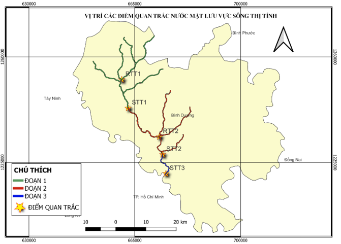
Vị trí các điểm quan trắc CLN mặt lưu vực sông Thị Tính
Phương pháp nghiên cứu
Phương pháp thu thập số liệu và phân tích
Số liệu được thu thập từ kết quả quan trắc CLN mặt của trung tâm quan trắc Kỹ thuật- Môi trường Bình Dương từ tháng 4/2022 đến tháng 3/2024. Phương pháp lấy mẫu được thực hiện theo (TCVN 6663-1:2011, TCVN 6663-3:2008, TCVN 6663-6:2008); bảo quản và vận chuyển mẫu (TCVN 6663-14: 2000). Trung tâm Quan trắc Tài nguyên và Môi truờng Tỉnh Bình Dương thu mẫu quan trắc liên tục với tần suất 1 tháng/lần17.
Phương pháp tính toán chỉ số WQI
Công thức tính giá trị WQI dựa trên Quyết định 1460/QĐ-TCMT của Tổng cục môi trường Việt Nam16.
Các thông số sử dụng để đánh giá WQI của nghiên cứu tập trung vào 3 nhóm chính:
Nhóm I: Thông số pH.
Nhóm IV: Thông số DO, COD, N-NH, N-NO, N-NO, P-PO và nhiệt độ, trong đó thông số nhiệt độ là thông số phụ để tính toán DO% bão hòa phục vụ cho việc tính toán giá trị WQI của thông số DO.
Nhóm V: Thông số coliform.
Công thức tính toán WQI cuối cùng áp dụng như sau16:
Trong đó:
WQI: Kết quả tính toán đối với thông số nhóm I
WQI: Kết quả tính toán đối với thông số nhóm II
WQI: Kết quả tính toán đối với thông số nhóm III
WQI: Kết quả tính toán đối với thông số nhóm IV
WQI: Kết quả tính toán đối với thông số nhóm V
Quy trình tính toán như sau:
Bước 1: Thu thập các số liệu quan trắc: pH, nhiệt độ, DO, COD, N-NH, N-NO, N-NO, P-PO, coliform.
Bước 2: Tính toán các giá trị WQI thông số
Bước 3: Tính toán WQI cuối cùng.
Thang đánh giá CLN
|
Giá trị WQI |
Chất lượng nước |
Phù hợp với mục đích sử dụng |
Màu sắc |
|
91-100 |
Rất tốt |
Sử dụng tốt cho mục đích cấp nước sinh hoạt |
Xanh nước biển |
|
76-90 |
Tốt |
Sử dụng cho mục đích cấp nước sinh hoạt nhưng cần các biện pháp xử lý phù hợp |
Xanh lá cây |
|
51-75 |
Trung bình |
Sử dụng cho mục đích tưới tiêu và các mục đích tương đương khác |
Vàng |
|
26-50 |
Kém |
Sử dụng cho giao thông thủy và các mục đích tương đương khác |
Da cam |
|
10-25 |
Ô nhiễm nặng |
Nước ô nhiễm nặng, cần các biện pháp xử lý trong tương lai |
Đỏ |
|
<10 |
Ô nhiễm rất nặng |
Nước nhiễm độc, cần có biện pháp khắc phục, xử lý |
Nâu |
Phương pháp so sánh
Đánh giá CLN bằng cách so sánh thông số WQI giữa mùa mưa và mùa khô theo thời gian và theo không gian, đồng thời cũng so sánh CLN của sông Thị Tính với các sông trên địa bàn của khu vực khác và của tỉnh khác. So sánh chỉ số WQI với thang đánh giá CLN theo Quyết định 1460/QĐ-TCMT của Tổng cục môi trường Việt Nam.
Phương pháp GIS
Nghiên cứu ứng dụng phần mềm QGIS, đây là phầm mềm quản lý dữ liệu, đọc được nhiều định dạng dữ liệu, biên tập và xuất bản bản đồ, xuất-nhập dữ liệu và các chức năng phân tích không gian cũng như sử dụng IDW trong QGIS để nội suy kết quả WQI thể hiện theo chiều dọc của sông Thị Tính.
IDW là một chức năng trong QGIS giúp tính toán một số liệu chính xác cho những vị trí mà không được đo hoặc lấy mẫu dựa vào những vị trí đã được đo mẫu. Phương pháp IDW xác định giá trị của các điểm chưa biết bằng cách tính trung bình trọng số khoảng cách các giá trị của các điểm đã biết giá trị trong vùng lân cận của mỗi pixel. Những điểm càng cách xa điểm cần tính giá trị càng ít ảnh hưởng đến giá trị tính toán, các điểm càng gần thì trọng số càng lớn.
Phương pháp xử lý số liệu
Tổng hợp thống kê số liệu bằng phần mềm Microsoft Excel 2020.
Xuất biểu đồ bằng Minitab 20.
Kết quả và thảo luận
Kết quả tính toán chỉ số WQI
Kết quả tính toán chỉ số WQI chia theo 3 tháng đầu mùa mưa, 3 tháng cuối mùa mưa, 3 tháng đầu mùa khô, 3 tháng cuối mùa khô theo Table 3.
Kết quả tính WQI
|
STT |
Ký hiệu |
3 Tháng đầu mùa mưa (4/2022-6/2022) |
3 tháng cuối mùa mưa (7/2022-9/2022) |
3 Tháng đầu mùa khô (10/2022-12/2022) |
3 tháng cuối mùa khô (01/2023-03/2023) |
3 Tháng đầu mùa mưa (4/2023-6/2023) |
3 tháng cuối mùa mưa (7/2023-9/2023) |
3 Tháng đầu mùa khô (10/2023-12/2023) |
3 tháng cuối mùa khô (01/2024-03/2024) |
|
1 |
STT1 |
83 |
89 |
84 |
81 |
75 |
89 |
80 |
84 |
|
2 |
STT2 |
79 |
85 |
73 |
80 |
88 |
85 |
84 |
74 |
|
3 |
STT3 |
88 |
81 |
77 |
85 |
86 |
83 |
83 |
92 |
|
4 |
RTT1 |
89 |
94 |
84 |
93 |
91 |
97 |
93 |
89 |
|
5 |
RTT2 |
80 |
67 |
75 |
80 |
79 |
79 |
85 |
79 |
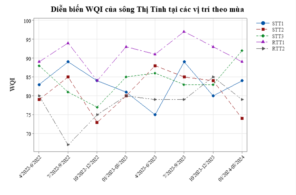
Diễn biến WQI của sông Thị Tính theo mùa
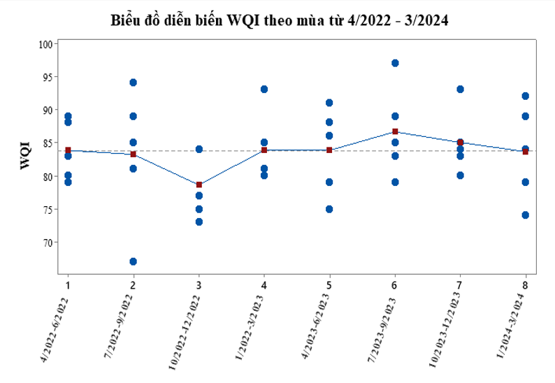
Diễn biến WQI sông ThịTính từ 04/2022-03/2024
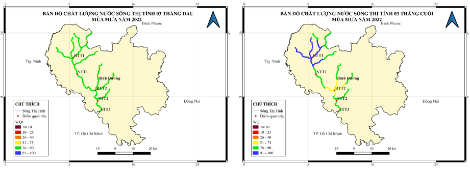
Bản đồ CLN của sông Thị Tính mùa mưa năm 2022
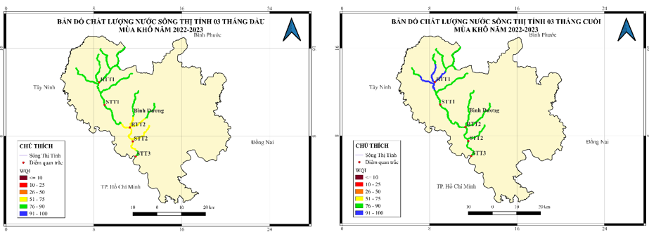
Bản đồ CLN của sông Thị Tính mùa khô năm 2022-2023
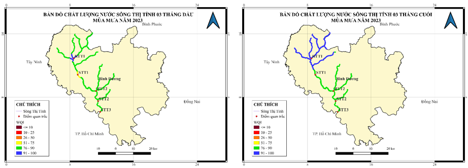
Bản đồ CLN của sông Thị Tính mùa mưa năm 2023
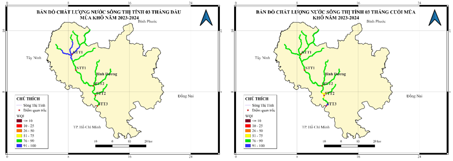
Bản đồ CLN của sông Thị Tính mùa khô năm 2023-2024
Đánh giá CLN sông Thị Tính theo không gian và thời gian
Theo không gian
Khu vực nghiên cứu được trải dài từ đầu nguồn sông Thị Tính vị trí giáp ranh giới tỉnh Bình Phước đến vị trí sông Thị Tính đổ vào sông Sài Gòn tại cầu Ông Cộ. Dựa trên vị trí địa lý của các vị trí quan trắc, tạm chia theo lưu vực sông Thị Tính thành ba đoạn như sau:
Đoạn 1: Khu vực thượng lưu sông Thị Tính từ giáp ranh tỉnh Bình Phước, suối Căm Xe, cầu Phú Bình (từ RTT1 đến STT1).
Đoạn 2: Khu vực trung lưu sông Thị Tính từ cầu Phú Bình, suối Cầu Quan, cầu trên đường Vành Đai 4 (từ STT1 đến STT2).
Đoạn 3: Khu vực hạ lưu sông Thị Tính từ cầu trên đường Vành Đai 4 tới cầu Ông Cộ vị trí đổ về sông Sài Gòn (từ STT2 đến STT3).
Dựa vào biểu đồ chỉ số CLN theo khu vực từ năm 2022 đến 2024 (Figure 2, Figure 3, Figure 4, Figure 5, Figure 6, Figure 7) vàTable 2 cho thấy:
Chỉ số WQI của sông Thị Tính trong thời gian nghiên cứu có WQI=67-97 và có sự khác biệt giữa 3 đoạn. Chỉ số WQI trung bình đoạn 1 (75-97) tốt hơn CLN trung bình của đoạn 2 (73-88) và đoạn 3 (77-92). CLN giảm dần tại đoạn 2 cải thiện lại tốt hơn ở cuối đoạn 3.
Chỉ số WQI đoạn 1 cao hơn khoảng 7 đơn vị so với đoạn 2 và 3 đơn vị so với đoạn 3. Chỉ số WQI đoạn 3 cao hơn khoảng 5 đơn vị so với đoạn 2.
Nguyên nhân có sự khác biệt CLN giữa 3 đoạn trong khu vực nghiên cứu chủ yếu do vị trí địa lý, các nguồn thải lân cận và đặc điểm khí tượng thuỷ văn.
Đoạn 1 nằm ở thượng lưu có nguồn tiếp nhận nguồn nước sạch hầu như các hoạt động kinh tế trên lưu vực đoạn này đều là hoạt động nông nghiệp và chăn nuôi, hầu như rất ít hoạt động công nghiệp, mật độ dân số còn chưa cao vì vậy mà CLN còn tốt, nước thải chảy qua khu vực này có các thông số coliform, N-NO, N-NH và P-PO cao.
Trong khi đó, đoạn 2 chảy qua khu vực trung tâm thành phố Bến Cát, tập trung nhiều khu công nghiệp với nhiều ngành nghề đa dạng như giấy, gỗ, thức ăn gia súc, thực phẩm, rượu…và khu dân cư đông đúc cũng như hoạt động chăn nuôi dạng công nghiệp. Do đó, đoạn 2 phải tiếp nhận nguồn nước thải công nghiệp từ các khu công nghiệp như khu công nghiệp Mỹ Phước I, II, Bàu Bàng, Lai Hưng, Cây Trường… các cơ sở sản xuất phân tán, nước thải chăn nuôi, nước thải sinh hoạt từ các khu đô thị, nước thải khu vực này bị ô nhiễm bởi các thông số lần lượt là N-NH, COD, N-NO và coliform.
Đoạn 3 nằm ở vùng hạ lưu của Thị Tính lưu vực có tập trung một số khu công nghiệp như khu công nghiệp Quốc tế Protrade, Việt Hương 2, Thới Hòa, Mỹ Phước 3 và khu vực dân cư này không tập trung nhiều và chủ yếu ở đoạn phía đầu của đoạn 3, càng về phía hạ lưu sông Thị Tính được tiếp nhận nguồn nước từ nhiều kênh rạch nội đồng nhờ vậy mà CLN cuối đoạn 3 ngày càng cải thiện hơn nhiều so với đầu đoạn 3. Nguyên nhân gây giảm CLN của đoạn này chủ yếu bởi các thông số lần lượt là N-NH, N-NO, coliform và COD.
Theo thời gian
Dựa vào biểu đồ chỉ số CLN theo khu vực từ năm 2022 đến 2024 (Figure 2, Figure 3, Figure 4, Figure 5, Figure 6, Figure 7 ) và Table 2 cho thấy: CLN có sự thay đổi giữa các năm, các mùa trong năm cũng như có sự thay đổi giữa 03 tháng đầu và 03 tháng cuối của cùng một mùa trong năm. CLN vào cả hai mùa mưa đều tốt hơn so với chất lượng mùa khô. CLN năm 2023-2024 tốt hơn so với năm 2022 đồng thời CLN các mùa trong năm 2023-2024 có xu hướng ổn định và ít biến thiên hơn so với cùng kỳ năm 2022.
Figure 4 cho thấy CLN sông Thị Tính 03 tháng đầu mùa mưa năm 2022 xấu hơn so với 03 tháng cuối mùa mưa. Đoạn 1 và đoạn 2 có nhiều thay đổi giữa 03 tháng đầu mùa và 03 tháng cuối mùa, cuối mùa mưa thì đoạn 1 có CLN cải thiện hơn so với đầu mùa mưa ngược lại đoạn 2 lại có CLN xấu hơn so với đầu mùa mưa. Chỉ số WQI giai đoạn mùa mưa 2022 dao động từ 67 đến 94. Kết quả WQI này tốt hơn so với suối Cầu Định năm 2017 với chỉ số WQI từ 24 đến 352 và cũng tốt hơn nhiều so với kết quả WQI tại rạch Cây Bàng năm 2017 với WQI từ 35-462 . Nguyên nhân làm suy giảm CLN giai đoạn này chủ yếu là do các thông số coliform, N-NO, COD và N-NH cao.
Figure 5 cho thấy CLN 03 tháng đầu mùa khô xấu hơn so với 03 tháng cuối mùa khô năm 2022-2023. Cả hai đoạn 1, 2 đều có chất lượng vào đầu mùa khô xấu hơn so với cuối mùa khô. Chỉ số WQI giai đoạn mùa khô 2022-2023 dao động từ 73 đến 93. Kết quả WQI này tốt hơn nhiều so với mùa khô năm 2017 của sông Thị Tính với chỉ số WQI từ 16 đến 842. Nguyên nhân làm suy giảm CLN giai đoạn này chủ yếu là do các thông số N-NH, N-NO, P-PO và coliform cao.
Figure 6 cho thấy CLN sông Thị Tính 03 tháng cuối mùa mưa năm 2023 tốt hơn so với 03 tháng đầu mùa mưa. Đoạn 1 đầu mùa mưa xấu hơn so với đoạn 1 cuối mùa mưa. Một phần đầu đoạn 2 vào đầu mùa mưa cũng có xấu hơn so với cuối mùa mưa. Chỉ số WQI mùa mưa năm 2022 dao động từ 75 đến 97. Kết quả này tốt hơn so với mùa mưa năm 2022 với chỉ số WQI từ 67 đến 94. Nguyên nhân làm suy giảm CLN giai đoạn này chủ yếu là do các thông số N-NH, P-PO, N-NO, Coliform cao. Kết quả WQI tốt hơn so với suối Bến Trắc năm 2017 với chỉ số WQI từ 61 đến 692 và tốt hơn nhiều lần so với WQI tại rạch Chòm Sao- Suối Đờn-rạch Vàm Búng năm 2017 với WQI từ 31-712.
Figure 7 cho thấy CLN 03 tháng đầu mùa khô tốt hơn so với 03 tháng cuối mùa khô năm 2023-2024. Đoạn 1 cuối mùa khô xấu hơn so với đầu mùa khô, đồng thời cuối đoạn 2 và đầu đoạn 3 cũng có CLN xấu hơn so với đầu mùa khô. Chỉ số WQI giai đoạn mùa khô 2023-2024 dao động từ 74 đến 93. Kết quả này tốt hơn nhiều so với mùa khô năm 2017 với chỉ số WQI từ 16 đến 842. Nguyên nhân làm suy giảm CLN giai đoạn này chủ yếu là do các thông số N-NO, N-NH, COD, P-PO cao.
Nguyên nhân có sự cải thiện của CLN năm 2023-2024 so với năm 2022 là nhờ sự quản lý chặt chẽ các nguồn thải của sở ban ngành cũng như dân số. Cùng với đó nguyên nhân có thể còn do tại điểm d khoản 2, Điều 45- Luật bảo vệ môi trường năm 2020 quy định cơ sở sản xuất, kinh doanh, dịch vụ, khu sản xuất, kinh doanh, dịch vụ tập trung, cụm công nghiệp đã đi vào vận hành chính thức phải có giấy phép môi trường trước ngày 31/12/2024. Dẫn đến các doanh nghiệp phải thực hiện tốt các yêu cầu về bảo vệ môi trường, thực hiện cải tạo, xây dựng bổ sung, vận hành ổn định …. đạt các quy chuẩn cho phép xả thải đủ điều kiện để lập hồ sơ đề xuất cấp giấy phép môi trường.
Figure 2, Figure 3 cho thấy CLN tại RTT2 vào thời điểm mùa mưa tháng 7/2022 -09/2022 có CLN xuống thấp nhất (WQI =67) so với tất cả các vị trí khác và các mùa khác trong thời gian từ tháng 4/2022 đến 03/2024. Đồng thời cho thấy vào thời điểm mùa khô tháng 10/2022 đến tháng 12/2022 có CLN thấp nhất so với các khoảng mùa khác trong nghiên cứu (WQI thấp hơn nhiều so với đường trung bình). Giai đoạn cuối mùa mưa từ tháng 07/2023 đến tháng 09/2023 có CLN cao nhất so với các khoảng khác trong nghiên cứu ((WQI cao hơn nhiều so với đường trung bình).
Như vậy nguyên nhân chủ yếu làm suy giảm CLN của sông Thị Tính là do các thông số N-NH, P-PO, coliform, N-NO và COD cao. CLN của sông Thị Tính từ tháng 4/2022 đến tháng 03/2024 (WQI =67-97) không tốt bằng CLN mặt của sông Đồng Nai đoạn từ bến phà Nam Cát Tiên đến bến đò Hãng Da (WQI =79-98) nhưng tốt hơn CLN sông Đồng Nai đoạn từ bến Phà Cát Lái đến Mũi Đèn Đỏ (WQI= 60-91) giai đoạn 2014-201610.
Kết luận
Từ kết quả nội suy WQI của sông Thị Tính theo các mùa từ năm 2022-2024 cho thấy CLN của sông Thị Tính vào mùa mưa tốt hơn so với CLN vào mùa khô và đang có xu hướng dần cải thiện cụ thể là WQI trung bình của khu vực từ giáp ranh tỉnh Bình Phước, suối Căm Xe, cầu Phú Bình (WQI=75-97), nguyên nhân gây ô nhiễm chủ yếu là do hoạt động chăn nuôi và nông nghiệp với các thông số coliform, N-NO, N-NH và P-PO cao; khu vực từ cầu Phú Bình, suối Cầu Quan, cầu trên đường Vành Đai 4 (WQI=73-88), khu vực từ cầu trên đường Vành Đai 4 tới cầu Ông Cộ vị trí đổ về sông Sài Gòn 3 (WQI=77-92), nguyên nhân chủ yếu do các hoạt động của các khu công nghiệp, khu dân cư với các thông số N-NH, COD, N-NO và coliform cao.
Khu vực sông Thị Tính từ cầu Phú Bình, suối Cầu Quan, cầu trên đường Vành Đai 4 có CLN xấu hơn so với các khu vực còn lại của sông. Nguyên nhân là do vị trí khu vực này có mật độ dân cư cao và nhiều khu công nghiệp lớn dẫn đến xả thải nhiều nước thải sinh hoạt và nước thải công nghiệp.
Nhằm duy trì xu hướng cải thiện nước mặt của sông Thị Tính cần có nhiều biện pháp quản lý như: yêu cầu sự tuân thủ của các cơ sở, nhà máy, xí nghiệp phải đảm bảo xử lý nước thải đạt quy chuẩn trước khi thải ra nguồn tiếp nhận; thường xuyên thanh tra, kiểm tra, quản lý chặt chẽ trong việc bảo vệ môi trường; thực hiện xây dựng các khu xử lý nước thải sinh hoạt tập trung cho đô thị.
Nghiên cứu mới chỉ tập trung nghiên cứu đánh giá diễn biến chất lượng nước mặt nên cần phải bổ sung thêm nghiên cứu sâu hơn nhằm tìm ra các thông số chính gây ảnh hưởng tới CLN cũng như đề xuất giá trị cụ thể các thông số chính cần được kiểm soát nhằm đảm bảo WQI đạt được theo mục đích sử dụng của sông Thị Tính hiện nay. Hạn chế của IDW là các điểm càng xa thì trọng số càng nhỏ nên để tăng mức độ chính xác nên bổ sung thêm các điểm lấy mẫu nhằm tăng mức độ tin cậy hơn.
Lời cảm ơn
Nhóm nghiên cứu xin chân thành cảm ơn Trung tâm quan trắc Kỹ thuật- Môi trường Bình Dương đã giúp nhóm có bộ số liệu để thực hiện nghiên cứu này.
Xung đột lợi ích
Nhóm tác giả không có xung đột lợi ích với cá nhân hay tổ chức nào liên quan đến bài nghiên cứu.
Đóng góp của tác giả
Nhóm tác giả Lê Thị Tuyết, Trần Thị Kim Dung, Lê Nguyễn Hoài An, Huỳnh Thế An cùng thực hiện và thảo luận với nhau để hoàn thành bài báo. Trong đó Lê Thị Tuyết thực hiện chính phần tính toán WQI, biểu đồ diễn biến và thảo luận, Trần Thị Kim Dung và Lê Nguyễn Hoài An chịu trách nhiệm chính phần lập bản đồ nội suy. Huỳnh Thế An chịu trách nhiệm thảo luận, kết luận, chỉnh sửa toàn bộ bài báo.
Kinh phí
Nghiên cứu này thực hiện bởi chính nhóm tác giả.